Urban
As a GenesisII user you may have a requirement to depict an urban area in your
landscape. However towns and cities are complex structures containing many hundreds
of man-made buildings and it is simply not feasible to add these individually
- nor in most cases is it necessary at is simply the presence of an urban area
we wish to convey.
GenesisII handles this situation by using Urban Plans. An Urban Plan
is simply an abstract description of what an urban area will look like, enough
control is available so you can control in general terms what your urban area
will look like, but the drawing of individual buildings is handled internally
by GenesisII.
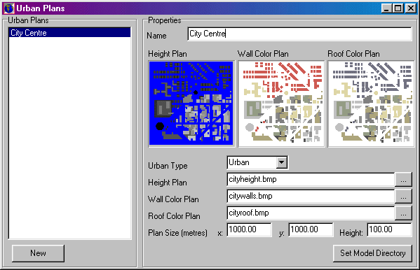
Urban Editor

Urban Plans
Plan list: List the plan available. Click Add to add a plan.
Select a plan to edit it's properties.
Properties
- Name: An arbitrary name assigned to each plan. Does not have to be
unique - although this is recommended.
- Urban Type: The type of buildings that will be drawn. Currently limited
to Urban (high rise residential and commercial buildings), Suburban (small
to medium family houses and shops), and Industrial (industrial plant and related
buildings). Other types will be available in future versions.
- Height Plan: A bmp file containing information about heights. GenesisII
tiles the plan over the terrain, and samples this bitmap in each terrain square
it draws to obtain the height of the building to draw at that point. Heights
are obtained by scaling the red channel of the image.
- Wall Color Plan: A bmp file sampled in a similar manner to heights,
but with the sampled color being used to draw th buildings walls..
- Roof Color Plan: As for Wall Color Plan, but used to draw roofs.
- Plan Size: Size information for drawing the urban plan. The plan
images will be scaled using these values.
- Set Model Directory: Sets directory path for urban plan bitmaps (this
is the same directory as used for 3D models).

